A Challenging yet Rewarding Hike Above the Clouds
The Rurimeria Trail is one of Kenya’s most scenic and demanding hikes, offering an unforgettable adventure through the Aberdare Ranges. Known for its steep ascents, high-altitude bogs, and stunning ridgeline views, this trail is not for the faint of heart but promises incredible rewards for determined hikers.
Located in Nyandarua County, the trail leads adventurers into the moorlands of the Aberdares, through unique alpine vegetation and dramatic landscapes. The Rurimeria Trail is popular among experienced hikers training for tougher expeditions like Mount Kenya or Kilimanjaro, but it also attracts nature enthusiasts eager to push their limits while enjoying the pristine beauty of Kenya’s highlands.
Location and Geography of the Rurimeria Trail
Where the Rurimeria Trail is Found
The Rurimeria Trail is tucked within the scenic Aberdare Ranges, close to Engineer town in Nyandarua County. Access is via the Ndunyu Njeru side of the Aberdare Conservation Area, making it one of the less-traveled routes into the highlands. From Nairobi, it’s about 120 kilometers away—roughly a 3–4 hour drive, depending on traffic and weather conditions.
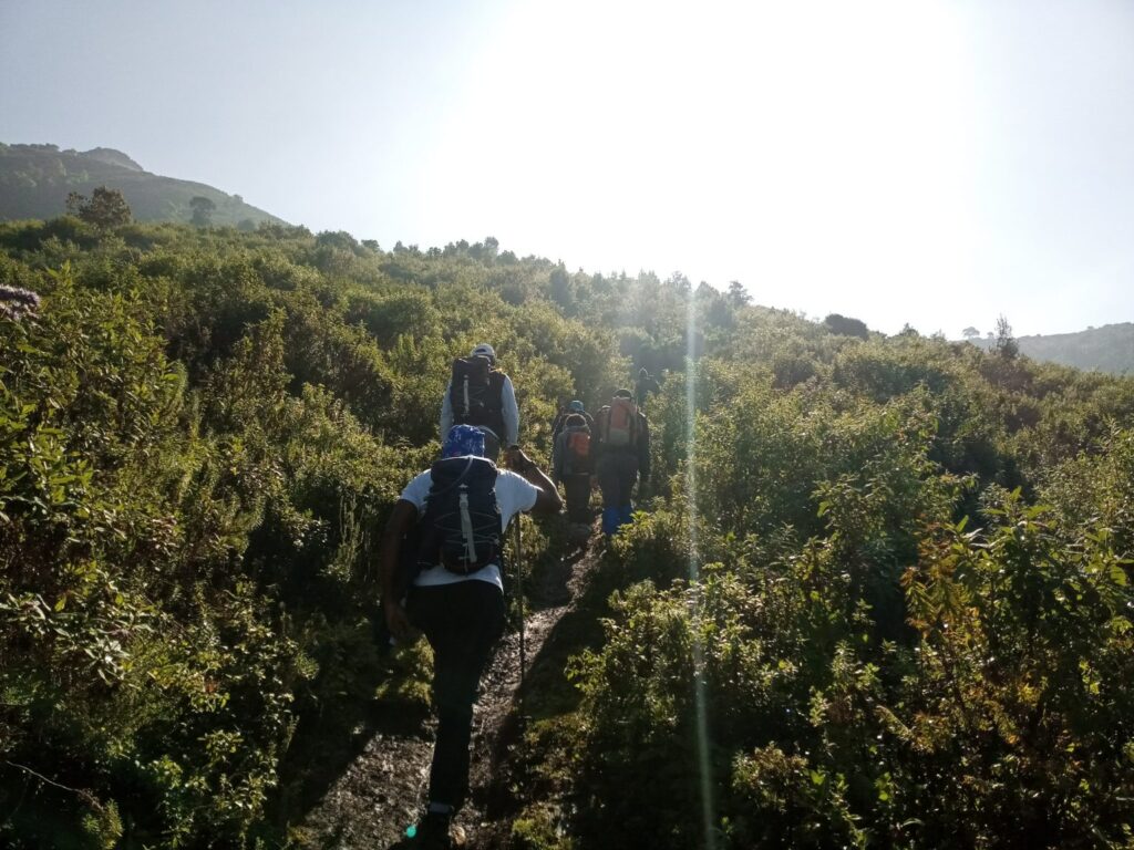
The trail begins in cultivated farmlands at the foothills, giving hikers a glimpse of rural Kenyan life, before ascending steeply into the montane forest. From here, the hike moves through dense bamboo forests, which are often misty and mysterious, before opening up into the iconic Aberdare moorlands that define the high-altitude sections of the Rurimeria Trail.
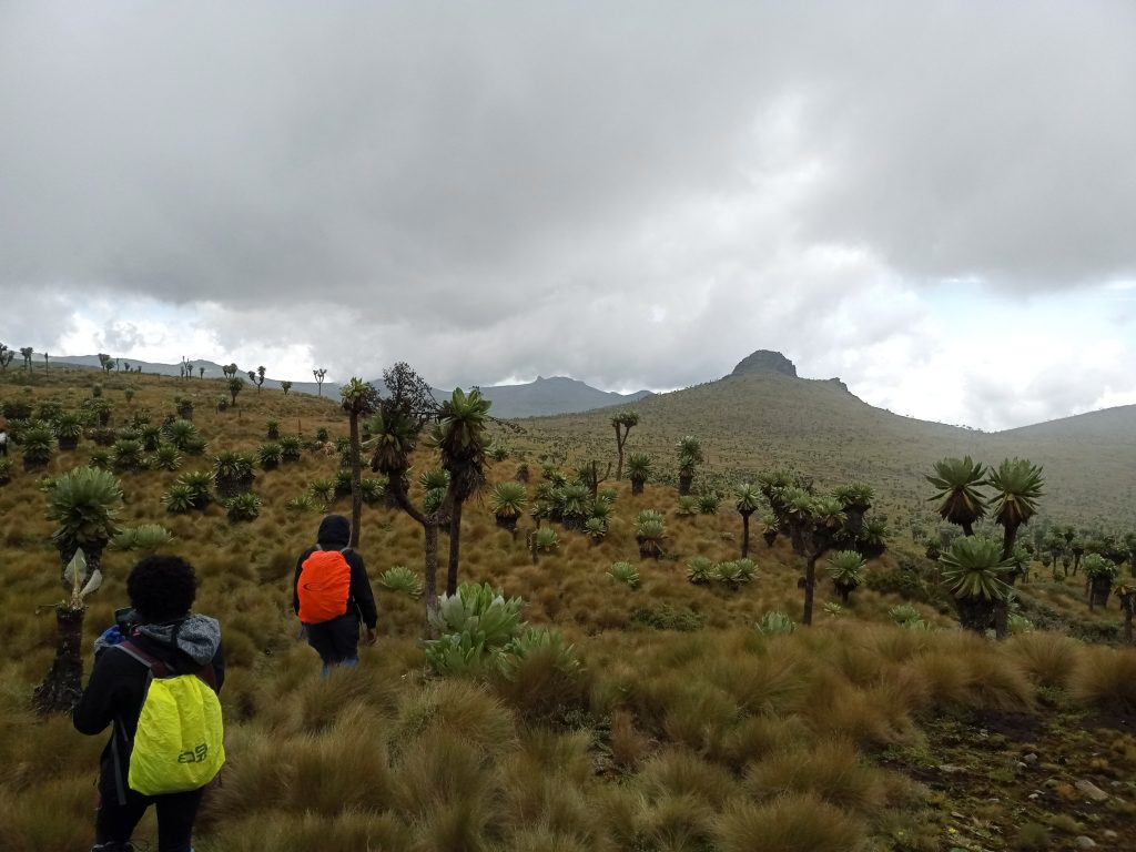
Natural Landscape
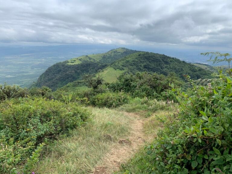
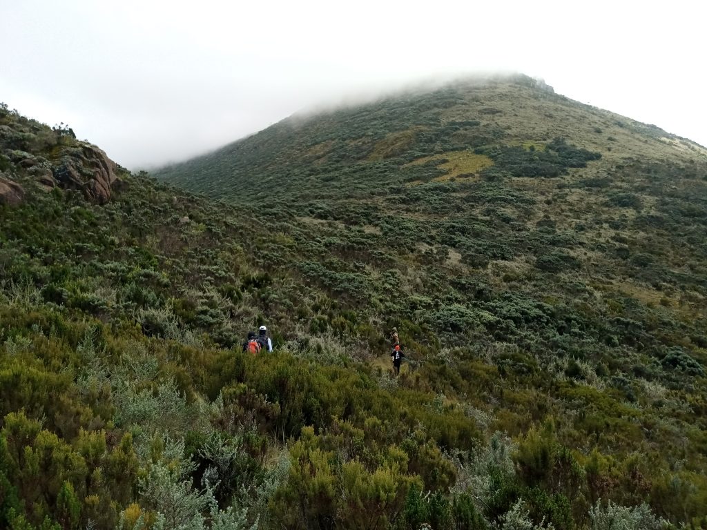
The Rurimeria Trail climbs to altitudes exceeding 3,800 meters above sea level, placing hikers in one of Kenya’s most unique ecosystems. The landscapes are striking, with giant lobelias standing tall among tussock grasses, alpine bogs stretching out like natural carpets, and hardy heather shrubs painting the hillsides.
As hikers move along ridges and valleys, they are treated to breathtaking views of Mount Satima and, on especially clear days, the snow-capped peaks of Mount Kenya in the distance. These transitions—from farmlands to bamboo forests to alpine moorlands—make the trail an ecological journey, showcasing the rich diversity of the Aberdares.
The Hiking Experience on the Rurimeria Trail
Difficulty Level
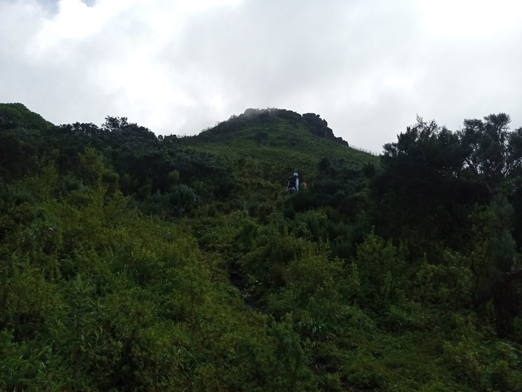
The Rurimeria Trail is widely considered one of the more challenging hikes in the Aberdares. Its steep gradients demand stamina, while boggy and slippery sections test balance and patience. The unpredictable highland weather adds another layer of difficulty—sunshine, mist, rain, and biting cold can all occur in a single day. However, the challenge is part of the charm, and the sense of victory at the summit is unmatched.
Duration and Distance
Most hikes on the Rurimeria Trail take 6–8 hours round trip, covering between 18–20 kilometers depending on the exact route taken. Early starts are highly recommended, not only to maximize daylight but also to avoid the thick fog that often rolls in by afternoon, obscuring visibility on the ridges.
The Summit Experience
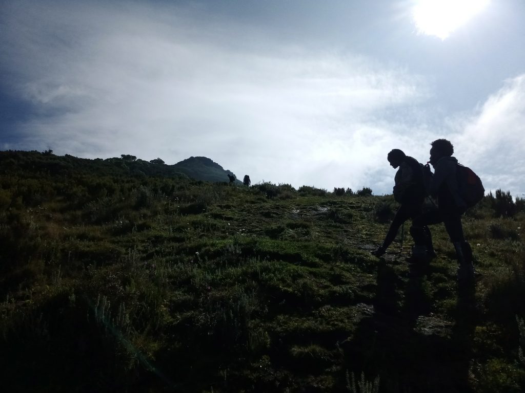
The culmination of the trail is Rurimeria Hill, a ridge that provides sweeping 360-degree views of the Aberdare highlands. From this vantage point, hikers can admire the Kinangop Plateau, Mount Satima, and even glimpses of Mount Kenya shimmering on the horizon. Standing here, surrounded by the vast moorland, gives hikers the exhilarating sensation of being “on top of the world.”
Unique Features of the Rurimeria Trail
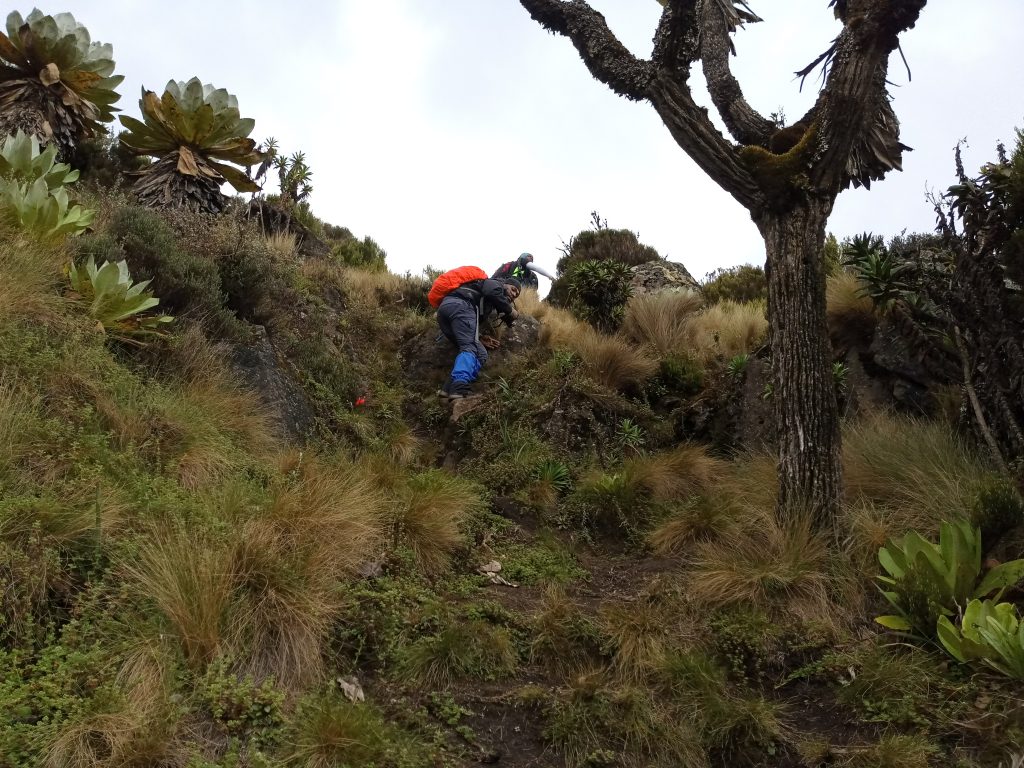
The Bamboo and Heather Zone
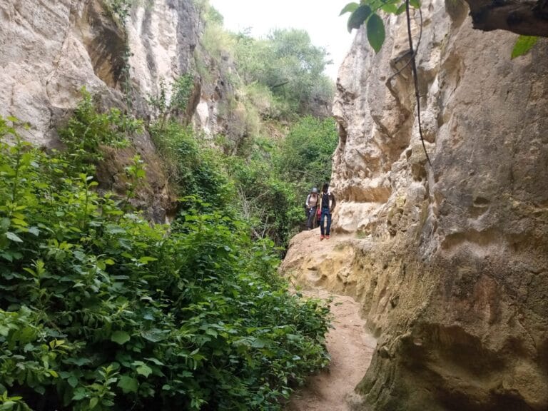
After leaving the farmlands, hikers enter a thick bamboo zone. This section is often damp and slippery, with narrow passages that make footing tricky. Emerging from the bamboo, hikers enter the heather zone, where shrubs dominate and the air feels cooler and fresher. This transition marks the shift into the moorland environment, which is dotted with alpine flowers and hardy vegetation adapted to the altitude.
The Alpine Bogs
Perhaps the most famous—and challenging—feature of the Rurimeria Trail is its alpine bogs. These soggy, waterlogged areas demand slow and careful movement, with some sections forcing hikers to hop from tussock to tussock to avoid sinking into the mud. Though exhausting, the bogs showcase the unique hydrology of the Aberdare ecosystem and make the trail truly distinctive.
Flora and Fauna
The trail is alive with unique plant life, including giant lobelias, senecios, and tussock grasses, all adapted to survive the cold, misty conditions. Wildlife encounters are also possible—lower down, hikers might spot bushbucks and colobus monkeys, while bird enthusiasts can enjoy sightings of malachite sunbirds, eagles, and Jackson’s francolins soaring or flitting across the ridges.
Why Hike the Rurimeria Trail?
Perfect Training Ground
Because of its high altitude and challenging terrain, the Rurimeria Trail is frequently used by climbers as a training ground for bigger expeditions like Mount Kenya or Kilimanjaro. It provides an excellent opportunity to test stamina, acclimatize to altitude, and build resilience.
Stunning Scenery
From mist-draped ridges to panoramic views of valleys and neighboring peaks, the trail offers photographers and nature lovers endless opportunities for breathtaking shots. The dramatic play of light and cloud over the moorland is especially magical.
Less Crowded
Unlike more popular trails in the Aberdares, the Rurimeria Trail remains relatively quiet. This solitude enhances the hiking experience, allowing trekkers to connect deeply with nature and enjoy peaceful moments of reflection.
Travel Guide to the Rurimeria Trail
Best Time to Visit
The best time to attempt the Rurimeria Trail is during the dry months of January–March and June–October. During the rainy seasons, the bogs swell with water and the trail becomes dangerously muddy, making progress slow and sometimes unsafe.
What to Pack
- Waterproof hiking boots to handle bogs and slippery terrain
- Trekking poles to maintain balance on steep ascents
- Warm clothing and rain gear as weather can change rapidly
- Sufficient water and high-energy snacks for the long trek
- Camera and binoculars to capture wildlife and scenic views
Getting There
From Nairobi, take the Nairobi–Naivasha highway, branching off toward Engineer town in Nyandarua County. The last stretch to the trailhead can be rough, so a 4×4 vehicle is recommended, particularly in the rainy season.
Safety and Conservation
Safety Tips
- Always hike with an experienced guide familiar with the bogs and ridges.
- Begin the trek early to avoid the afternoon fog that often blankets the trail.
- Dress in layers—temperatures can swing from warm to freezing in minutes.
- Be mindful of altitude sickness symptoms like headaches or dizziness.
Conservation Efforts
The Kenya Forest Service, together with local community groups, actively work to conserve the fragile ecosystem of the Rurimeria moorlands. Visitors are encouraged to practice responsible tourism, which includes carrying out all litter, staying on marked paths, and respecting the delicate alpine vegetation.
Accommodation Options Near Rurimeria
Budget Stays
Affordable guesthouses in Engineer town offer simple accommodation for hikers who want to rest before or after the trek.
Mid-Range Options
Hotels in Naivasha and Nyahururu serve as comfortable bases, especially for groups exploring different parts of the Aberdares.
Camping
For those seeking a more adventurous experience, camping is possible with prior permits. Camping on the moorlands allows hikers to soak in the quiet, starry nights, though it requires preparation for the harsh weather conditions.
Also read:The 5 BEST Kenya Mountains For Hiking And Trekking In 2025
Wrap up
The Rurimeria Trail is not just a hike—it’s a test of endurance, resilience, and appreciation for Kenya’s highland beauty. From steep ascents and muddy bogs to breathtaking ridges and views stretching for miles, it embodies both challenge and reward. For hikers seeking to push themselves while discovering one of the Aberdares’ hidden gems, the Rurimeria Trail should be at the top of the list.
FAQs About the Rurimeria Trail
1. Where is the Rurimeria Trail located?
It’s in the Aberdare Ranges, near Engineer town in Nyandarua County.
2. How long is the Rurimeria Trail?
The hike is about 18–20 km round trip, taking 6–8 hours.
3. What is the altitude of the trail?
The trail climbs to over 3,800 meters above sea level.
4. Is the hike difficult?
Yes, it’s rated strenuous due to steep climbs, bogs, and altitude.
5. What wildlife can be seen?
Bushbucks, monkeys, and bird species like sunbirds and francolins.
6. Do I need a guide?
Yes, especially due to boggy sections and unpredictable weather.
7. Can beginners do the Rurimeria Trail?
It’s possible, but it’s best for hikers with moderate to advanced fitness.
8. When is the best time to hike?
During dry seasons—January to March, June to October.
9. What should I carry?
Waterproof boots, warm clothing, snacks, water, and trekking poles.
10. Why hike the Rurimeria Trail?
For its challenge, stunning moorland scenery, and training value for big climbs.